Authorized XGRIDS Reseller in Indonesia
Capture Reality at the Speed of Walking.
Next-generation Handheld SLAM LiDAR and 3D Gaussian Splatting solutions. Authentic units, local support, and field-tested expertise from Teknika Spasial Persada.
Beyond Scanning. True Spatial Computing
INTELLIGENT 3D RECONSTRUCTION
Traditional scanning separates geometry from visual reality. XGRIDS unites them. By fusing high-precision LiDAR with advanced Vision sensors, we bridge the gap between Engineering Surveying and Creative Digital Twins. Stop measuring point-by-point; start walking and capturing.
- Survey-Grade Accuracy (L2 Pro): Achieve 1cm relative accuracy with real-time processing, redefining efficiency for mining and construction.
- Cinematic Realism (PortalCam): Capture true-to-life environments with the world's first handheld 3D Gaussian Splatting (3DGS) camera.
- Unmatched Agility (K1): Navigate complex spaces effortlessly with ultra-lightweight devices (<1kg) designed for single-hand operation.
PRECISION REDEFINED
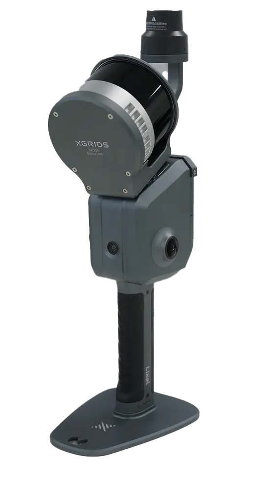
Lixel L2 Series
Real-Time Post-Processed Quality Point Clouds.
The Lixel L2 Pro fuses LiDAR, visual sensors, and IMU with AI to deliver post-processed quality point clouds in real-time. This breakthrough eliminates traditional processing delays, giving you professional results directly in the field while setting a new standard for SLAM efficiency. It features the exclusive LixelUpSample™ algorithm for denser point clouds and sharper detail.
- Achieves 1cm relative accuracy with a point cloud thickness of just 0.5cm
- Equipped with 2×48 Megapixel cameras to generate max 56MP panoramic images
- Built-in 1TB SSD to handle large-scale data capture
- Field-ready data without waiting—matching post-processing quality instantly.
Quick Specs
- Scanning Frequency: 320,000 / 640,000 points/s
- Operating Range: 0.5m ~ 120m / 300m
- LiDAR FOV: 360°×270°
- Weight: 1.7kg (without battery)
- Dimensions: 180mm x 130mm x 400mm
- Operation Time: 90 min continuous
- Storage: 1TB SSD
- Protection Level: IP54
COMPACT REALITY CAPTURE
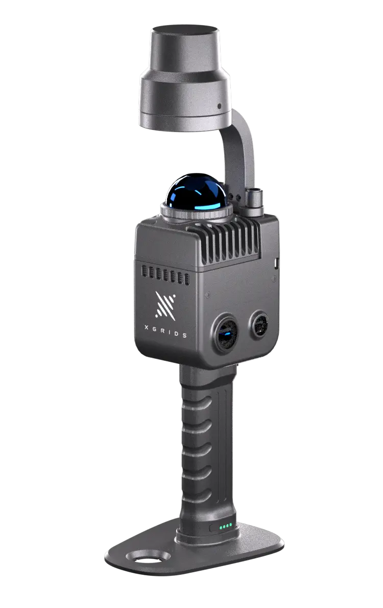
Lixel K1 Series
Compact Yet Powerful: 360° LiDAR & Panoramic Vision in Your Palm.
Redefine portable 3D scanning. Weighing just 1kg, the Lixel K1 features a navigational aluminum alloy body that seamlessly fuses 360° LiDAR with panoramic imaging. It delivers professional-grade, true-color point clouds instantly—transforming complex spatial capture into a simple, one-hand operation experience.
- 1kg aluminum body for effortless one-hand operation
- Integrated 4-camera system producing max 56MP panoramic images for zero-time coloring
- 1.2cm relative accuracy with a working range of up to 70m
- View detailed color point clouds live on your smartphone via the LixelGO App
Quick Specs
- Scanning Frequency: 200,000 Points/s
- Operating Range: 0.1m ~ 40m @ 10% / 70m @ 80%
- LiDAR FOV: 360° × – 7 ~ + 52°
- Weight: 1kg
- Operation Time: 90 min
- Storage: 256GB TF Card
- Protection Level: IP54
THE FIRST TRUE SPATIAL CAMERA
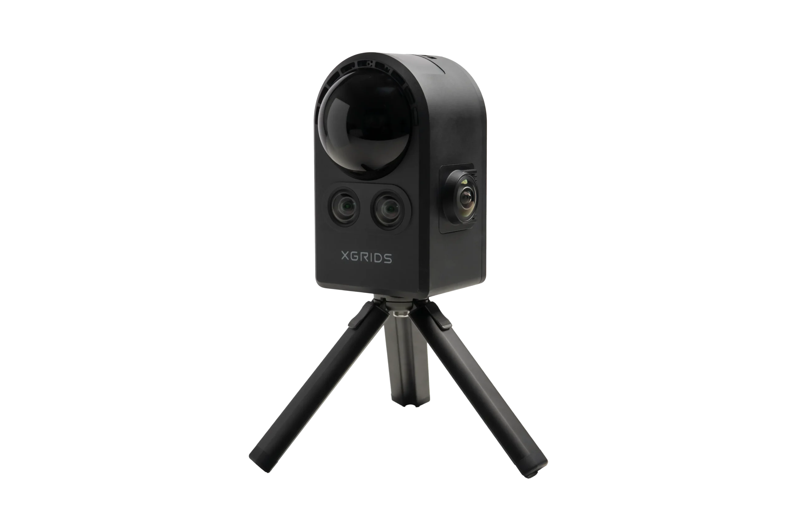
PortalCam
Capture Reality as Interactive 3D Environments
Meet PortalCam, the world’s first handheld device powered by 3D Gaussian Splatting (3DGS). It combines a 4-camera array with high-performance LiDAR to create photorealistic spatial models you can walk through. Weighing just 870g, it allows you to scan a 100m² space in just 10 minutes—capturing film-grade visual fidelity with true-to-life lighting and materials.
- Breakthrough Gaussian Splatting technology for photorealistic 3D models
- 4-Camera System (4000 x 3000 px) captures realistic textures and lighting
- Aerospace-grade aluminum body weighing only 870g (1.9 lbs)
- Smartphone-simple operation—scan vast parks or small rooms instantly
Quick Specs
- Technology: 3D Gaussian Splatting (3DGS) + LiDAR
- Camera: 4-Camera Array (4000 x 3000 px)
- LiDAR Range: 30m @ 10% / 60m @ 90%
- LiDAR Rate: 856,000 points/s
- Weight: 870g (without tripod)
- Storage: 512GB Internal
- Battery Life: 60 minutes (continuous)
- Workflow: Walk & Scan -> Automated AI Processing
Why Buy XGRIDS from Teknika?
We are not just a reseller. We are daily practitioners of the technology we sell.
Field-Tested Expertise
We don't just recite datasheets. Our team uses XGRIDS scanners in our own commercial survey projects. We provide recommendations based on real-world field experience, not sales scripts.
Comprehensive Local Training
Receive in-depth operational training. We teach your team not just how to press the button, but how to optimize SLAM workflows for complex environments.
Official Warranty & Service
Peace of mind guaranteed. We provide 100% authentic units with official manufacturer warranty support.
Dedicated Technical Support
Our relationship doesn't end at purchase. Access our engineering team for ongoing support, data processing, and troubleshooting whenever you need it.
Ready to Map Your Project’s Success?
Our experts bring extensive experience supporting diverse industries such as mining, oil and gas, renewable energy, forestry, and plantations. This expertise enables us to deliver solutions that meet technical requirements and create positive impacts across industries.

We are dedicated to developing solutions that keep pace with industrial technology trends. Our goal is to meet every client need through innovative, superior quality solutions at competitive rates.
Contact Us
- Jl. A. Yani No.245, Cihapit, Kec. Bandung Wetan, Kota Bandung, Jawa Barat 40114
- survey@teknikaspasial.co.id
- +62811228665